


Nagercoil LPA
About Nagercoil Local Planning Area
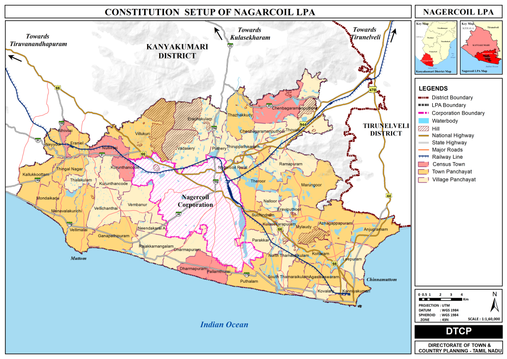
Nagercoil is a vibrant town located in the southernmost part of India, serving as the administrative headquarters of the Kanyakumari district in Tamil Nadu. Geographically, Nagercoil is positioned at approximately 8°10’44.31″ N latitude and 77°25’27.87″ E longitude. The Nagercoil Local Planning Area (LPA), formally known as the Nagercoil Composite Local Planning Area (CLPA), includes the Nagercoil City Municipal Corporation and 62 adjacent revenue villages. These villages have been bifurcated and reconstituted into Town Panchayats and Village Panchayats. Consequently, the Nagercoil LPA comprises One City Municipal Corporation, 21 Town Panchayats, and 41 Village Panchayats. The total geographical area of the Nagercoil LPA covers 438.86 Sq. Km.
Nagercoil Local Planning Area (LPA)
| Name of the LPA | Nagercoil |
|---|---|
|
CONSTITUTION OF THE LPA |
|
|
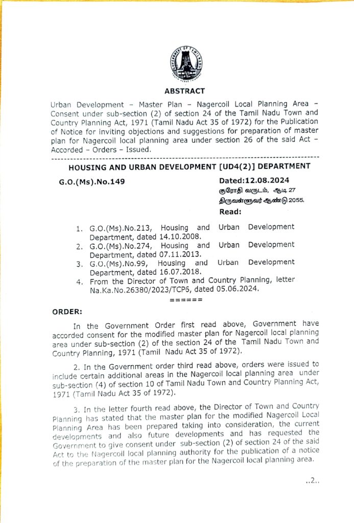
Date of Notification as per G.O.Ms. No: 213, H&UD |
14, Oct 2008 |
|
Existing Extent of the Nagercoil LPA |
176.07 Sq.km |
|
Date of Notification as per G.O.Ms. No: 152, H&UD |
22, Feb 1994 |
|
Existing Extent of the Kanyakumari LPA |
4.91 Sq.km |
| Inclusion Of Additional Area In The Lpa | Nagercoil LPA |
|---|---|
|
Date of Notification as per G.O.Ms. No: 99-10(4), H&UD |
16, Jul 2018 |
|
Added area |
257.88 Sq.km |
|
Total Extent of the LPA |
438.86 Sq.km |
|
Constituents of the LPA |
Numbers |
|
Municipal Corporation |
1 |
|
Town Panchayats |
21 |
|
Village panchayats |
41 |
|
Total Revenue Villages |
62 Revenue Villages |
|
Population of the LPA (2011) |
804995 |
*Note: 5 Reserved Forest Covering 17.28 Sq.km (2.02%)
Planning Area
The Tamil Nadu Town and Country Planning Act, 1971, an Act to provide for planning the development and use of rural and urban land in the State of Tamil Nadu, states (as per section 17) the Master Plan may provide for any or all of the following matters:
- The manner in which the land in the planning area shall be used;
- The allotment or reservation of land for residential, commercial, industrial and agricultural purposes and for parks, play-fields and open spaces;
- The allotment and reservation of land for public buildings, institutions and for civic amenities;
- The making of provision for national highways, arterial roads, ring roads, major streets, lines of communication including railways, airports and canals;
- The traffic and transportation pattern and traffic circulation pattern;
Downloads


News Paper Ads
Nagercoil Corporation - Landuse Maps
Rest of the LPA (Excluding Corporation) - Landuse Maps
FAQ'S
The Master plan is a statutory document that provides a guideline for future growth of town in a sustainable way over a plan period of 20 to 30 years. In Tamil Nadu Master Plan is prepared with the legislative support of Tamil Nadu Town and Country planning Act 1971. The Master plan includes analysis, recommendations, and proposals for a town’s economy, housing, transportation, physical infrastructure, social infrastructure. It is based on public input, surveys, planning initiatives, existing development, physical characteristics, and social and economic conditions. Finally the proposed Land use map is prepared on the basis of future requirements and proposals.
As the Master Plan is the document that prescribes land use, development control and building regulations, and policy recommendations that are adopted by different government departments, it plays a crucial role in defining the direction of growth of the city.
The Master Plan is important for investors and businesses to identify priority areas of interest and ensure that the development is in line with the government’s vision.
More importantly, the Master Plan is important to every citizen as the city’s growth affects everyday matters like the use of natural resources, transport, health, inclusivity, safety, quality of life, access to green spaces, vibrant public spaces, etc
The Nagercoil Local Planning Area (LPA), includes the Nagercoil Municipal Corporation and 62 adjacent revenue villages. These villages have been bifurcated and reconstituted into Town Panchayats and Village Panchayats. Consequently, the Nagercoil LPA comprises One Municipal Corporation, 21 Town Panchayats, and 41 Village Panchayats. The total geographical area of the Nagercoil LPA covers 438.86 Sq. Km.
The Master Plan is available in the form of reports and maps in the Downloads section of this website.
High resolution printed maps and report are available for viewing at: Downloads Section.
Nagercoil Local Planning Authority, District Town & Country Planning Office, District Collectorate Campus, Nagercoil, Kanyakumari District.